Projects
Willow Copper-Molybdenum Porphyry
Yerington, Nevada
Abacus Drilling
Drilling by the Company in 2018 and 2021 intersected a key intrusive rock unit on Willow that hosts all known porphyry Cu-Mo deposits at Yerington – the Luhr Hill granite. This rock unit was not previously known to exist on the Company’s property, and it represents a key new discovery, as there are no known instances in the camp where this granite exists without an associated porphyry deposit. The target is large (at least 2.2 km X 2 km) and robust, and it remains essentially untested. The figure below is a plan map of collar locations.
The target is blind, being covered by volcanics. These volcanics in the upper parts of the holes above the #13 fault are not sampled. Three holes were drilled in 2018, although the two furthest east were lost in faults. Two of these 2018 holes intersected the Luhr Hill granite although one was lost before it cored much of the granite. In 2021 three additional holes were drilled and all intersected the Luhr Hill granite.
One hole from 2018 and all three from 2021 hit significant composited intervals of low-grade copper and molybdenum mineralization, which are detailed in the table below. The holes were all well mineralized and altered, with Cu values in the 0.1-0.2% range over 1.8-3.0 m in AW81-002, and as high as 0.37% Cu over 1.1 m in AW21-001 and 0.38% Cu over 0.2 m in AW21-003. Mo is elevated in all holes which is a particularly strong indicator that you are close to a porphyry copper center.
The last value in the table below is grade (G) vs thickness (T), which gives an idea of the relative amount of mineralization present. The results indicate close proximity to a porphyry copper center and clearly indicate that further drilling is warranted.
| Hole | From | To | Interval (m) * | Cu_(%) | Mo_(ppm) | Cu GxT (%-m) |
| AW18-002 | 499.60 | 571.80 | 72.20 | 0.11 | 68.0 | 7.97 |
| AW21-001 | 478.00 | 535.50 | 57.50 | 0.118 | 96.0 | 6.76 |
| including | ||||||
| AW21-001 | 501.50 | 535.50 | 34.00 | 0.189 | 160.7 | 6.35 |
| AW21-002 | 239.80 | 548.20 | 308.40 | 0.079 | 47.6 | 24.4 |
| including | ||||||
| AW21-002 | 456.70 | 494.60 | 37.90 | 0.096 | 124.3 | 3.65 |
| AW21-003 | 426.00 | 428.50 | 2.50 | 0.12 | 20.0 | 0.30 |
*True widths are unknown but are estimated at 80-85% of the drilled interval
Sampling was mostly done on 0.6-1.7 m intervals over the bottom portion of each hole, but the sampling was not continuous. There were 42 samples taken over 570 m in AW18-002, 55 samples taken in AW21-001 over 239 m, 48 samples in AW21-002 over 364 m and 47 samples taken in AW21-003 over 320 m. Intercepts are calculated weighted averages using Target software, with the assumption being that the intervals without analyses ran the same as the average. They are not intended for use in any future resource calculation, but instead to give an idea of the approximate grade and location of Cu and Mo mineralization.
In summary, Cu-Mo porphyry deposits at Yerington occur at the contact of the Luhr Hill granite porphyry and surrounding volcanic rocks, or else close to the granite but associated with porphyry dyke swarms further into the volcanic package. The Company analyses all drill holes for a large suite of geochemical elements, which provides a great deal of data to help vector into higher Cu grades. This work is complicated by the fact that the originally upright porphyry system is now lying on its side, with many of its features buried by later volcanics.
The Company’s target is essentially identical to the two largest porphyry deposits in the Yerington camp, namely the past-producing Yerington mine and the undeveloped Ann Mason deposit. Because the target at Willow is covered by later volcanism, prospecting by drill and sampling for geochemistry is the only effective means of trying to locate a porphyry center, and this often takes several drill campaigns to achieve, with each successive campaign vectoring closer to a porphyry center.
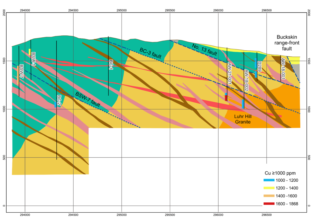
The figure above is the latest east-west long section of the property (looking north), showing copper intercepts in two of the Abacus holes, plus results from historic drilling. The Company continues to analyse the geochemical data from the last round of drilling, but it is evident that the 2021 drilling was done in close proximity to a porphyry copper deposit and further drilling is clearly warranted.
The entire area east of the green volcanics in the figure above remains prospective, both between the #13 and the BC-3 faults, and below the BC-3 fault. As the Company works further west, it is believed that higher copper grades may be present within 100 to 300 metres from surface.
The technical information in this section has been reviewed and approved by Paul G. Anderson, M.Sc. P.Geo., a Qualified Person within the meaning of National Instrument 43-101. It was written based on first-hand knowledge of the property, published geological papers and a review of adjacent company’s websites. The mineralization and/or resources/reserves of other properties in the district is not necessarily representative of the mineralization hosted on the Company’s Willow Property.

 Ajax, BC

