
Projects
 Ajax, BC
Willow Copper-Molybdenum Porphyry
Yerington, Nevada
Early Exploration by Abacus
Abacus initiated work on the Willow project in April of 2017. The Company compiled historic data, and then did detailed geological mapping, soil geochemistry, magnetic and IP geophysical surveys and relogging and sampling of historic skeleton core.
The geological mapping delineated altered rocks covering at least 16 km², over much of the Willow property. More intense alteration occurs in two, east-west, funnel shaped zones, with increasing sericitic, silicic and advanced argillic (alunite, pyrophyllite, diaspore, topaz, zunyite) alteration. The northern system covers an area of approximately 1.5 km north-south by 2.0 km northwest-southeast, while the southern zone is 2.5 km north-south by 2.5-3.0 km east-west.
The soil survey outlined broad, strong copper and molybdenum anomalies over the eastern part of the southern alteration zone, with several smaller anomalies to the west (see figure below). The northern alteration zone contained much weaker soil anomalies.
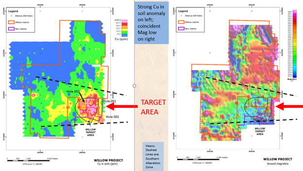
As work progressed, it became evident that the southern alteration zone was larger, with much stronger Cu-Mo soil geochemistry and that it contained a higher proportion of granite porphyry dyke swarms and frequent quartz veining, all of which increase in intensity to the east. Along with ground geophysics and other work described below, a 2.0 km by 2.2 km portion of this southern alteration zone has become the Company’s “Target Zone”.
The northern alteration zone is now thought to be the very top or lithocap of the large Ann Mason deposit to the east, and having no further porphyry copper potential, these claims were dropped in 2020.
Geophysical work entailed ground magnetics and IP. The Target Zone is marked by a magnetic high on the east side representing the Luhr Hill granite, with the high truncated by the Range Front fault to the east. It is flanked by a very broad magnetic low to the west (light blue in the figure above) which is interpreted to represent strongly hydrothermally altered rocks. A prominent IP anomaly straddles the Willow/Nev-Lorraine property boundary within the broad magnetic low and is thought to represent sulphide mineralization.
The Target Zone was further enhanced by analyzing rock and soil samples collected in 2017 with a spectrometer, which detects any hydrothermal minerals present. The results were then compared with a published 2015 model of hydrothermal alteration and geochemical dispersion around porphyry copper deposits, that was in large part based on studying the adjacent Ann Mason deposit. The model predicts that outward from a porphyry copper deposit, successive alteration halos of Cu, Mo, W, Sn and Se will be developed. The Willow and Nev-Lorraine properties contains this exact pattern within the Target Zone, providing a strong validation of the geological and geophysical interpretation.
In 2017 the Company was able to locate, relog and sample skeleton core from shallow 1970’s drilling at Willow. The vertical drilling, most of which was several km west of the new Target Zone, intersected a series of flat lying porphyry dykes with anomalous copper values, thought to represent the upper parts of a porphyry system, plus a series of flat, sub-parallel faults. By examining the geology and geochemistry of these drill holes, an estimation of displacement along these flat-lying faults was made.
An early version of the interpretation is presented in the figure below, a long section oriented east-west. It was evident by the end of 2017 that the dyke swarm intersected by the drilling in the 1970’s was unassociated to any known porphyry copper deposit. From the data collected by Abacus, it was thought that a new porphyry copper center lies beneath the southeast corner of the Willow property.
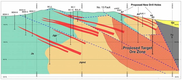
The Company believes that the flat-lying faults have displaced the original target zone at depth further to the west and closer to surface, within the Willow property, into an area not previously drilled. There is an area of approximately 1.4 km east-west that is undrilled between the 1970 era holes to the west and recent Abacus drilling.In summary, the Target Zone is defined by coincident geological, geochemical and geophysical signatures typical of a porphyry copper deposit. It is marked by a minimum 2.0 km by 2.2 km zone of intense sericitic, silicic and advanced argillic alteration, a high proportion of granite porphyry dyke swarms, and frequent quartz veining. It contains a very strong Cu-Mo geochemical anomaly coincident with a broad magnetic low and an IP high. Geochemical modelling indicates that the Target Zone lies in close proximity to a productive porphyry copper center. The Target Zone is analogous to the Ann Mason deposit to the east and the Yerington deposit further east, but it represents a separate porphyry copper center